The Collierville-Arlington Parkway connects I-40 at Arlington with Collierville. Collierville was the fastest growing city in Tennessee during the 1990s. The parkway replaces Collierville-Arlington Road (TN 205), a winding and dangerous two-lane road.
None of the parkway has been built. The first sections to be constructed will be from I-40 to just south of U.S. 64 near Eads and from U.S. 72 to TN 57 southeast of Collierville. It will be extended in several segments until it connects with the Nonconnah Parkway in southern Collierville. According to the Memphis MPO's proposed 2002-04 transportation improvement plan, several segments are scheduled for right-of-way acquisition and construction work (fiscal years):
| Segment | Right of Way | Construction |
|---|---|---|
| I-40 to U.S. 64 | 2002 | 2002 |
| U.S. 64 to TN 193 | 2002 | 2004 |
| TN 193 to TN 57 | 2002 | not scheduled |
| U.S. 72 to TN 57 | 2002 | 2003 |
The plan does not currently include any funding for a connector to MS 304, or any funding for MS 304 itself.
Since the highway has not been fully designed yet, it is difficult to say. The I-40 interchange was (mostly) built during the Paul Barret Parkway project, and will be a full cloverleaf. Other known interchanges:
Other interchanges are likely at Walnut Grove Road (if built), Wolf River Parkway/Shelton Road (if built), and Raleigh-LaGrange Road. Private developers have also expressed an interest in adding an interchange between U.S. 64 and I-40 for a proposed access road, but its status is uncertain.
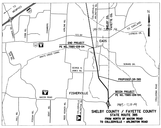
This segment is the only one I currently have detailed information on. It is approximately 3 miles long, and starts just north of Macon Road, ending at TN 205 just southwest of Eads. This project section has no interchanges.
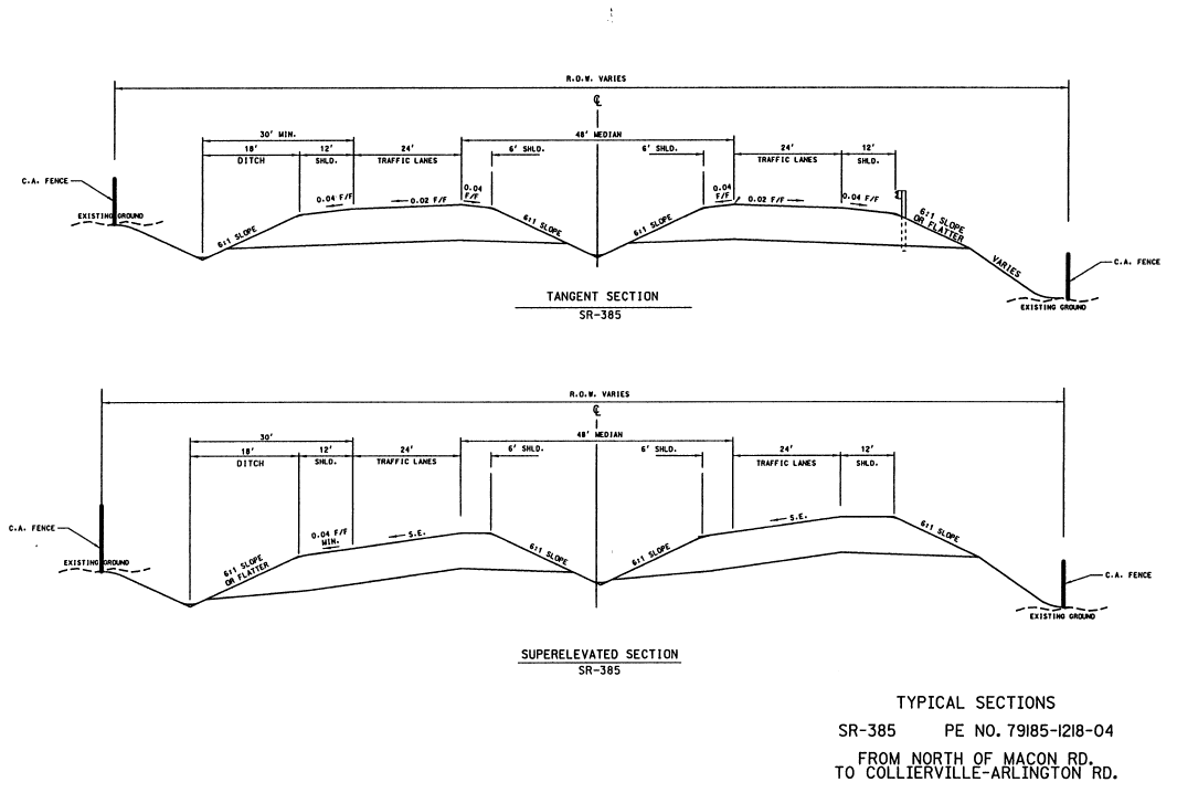
A rough map of the project, and two cross-section diagrams are available, from information provided at a public meeting on July 6, 2000.
Here is a post I made to misc.transport.road about the meeting:
Adam Froehlig let me know about this meeting today in Cordova (an
eastern suburb of Memphis).  The specific section being presented was
from south of U.S. 64 (SR 15), east of Eads, to just north of SSR 193
(Macon Road).  The actual project includes no interchanges (the Macon
Road interchange is in the next section to be designed, and the
northern end is actually the middle of SSR 205, the existing
Collierville-Arlington Road).  Presumably they expect construction on
the next segment to be underway when they are done, and for them to
build from north to south starting at the Macon interchange.

The maps on display show the Macon interchange as a simple diamond.
No interchange was shown at U.S. 64 (I'm sure there IS one, they
probably just didn't bother showing it since they don't need to design
the road to accomodate it).  There are bridges over George R. James Rd
and SSR 205; it also crosses Grays Creek, presumably with a bridge or
culvert or something.

According to the engineer I spoke to (one of the consultants on the
project), the design and land acquisition phases should be done by
mid-2001, with construction to start then, dependent on financing
(Tennessee budget issues, etc.).  He estimated completion somewhere
between 2003-2005.  Trivia: the guy I spoke to called TDOT "tee-dot",
and he lives near the Forest Hill-Irene interchange on 385 (the
Nonconnah Pkwy segment).

Construction will probably be done from the north to the south;
apparently the I-40 to U.S. 64 section is already designed.  There are
approximately 10-15 affected property owners, and no structures will
be displaced along the ~3 mile project.  The engineer said this few
property owners for 3 miles of road is virtually unheard-of.  The
largest plot was owned by Boyle Investment Co., a big developer (at
the proposed Macon interchange).

ADT estimates: 2001 - 3,810; 2021 - 26,670.  I don't know if the
latter number is consistent with I-69 being routed over this highway.

There was something called "DHV" which was estimated at 2667 in 2021.
I guess that means "daily heavy vehicles", or maybe something to do
with high-occupancy.  Whatever it is, it's 10% of the ADT.

[Update: Adam reports that this is the 30th highest hourly traffic
volume expected in a year, and that 10% of ADT is typical.]

The design speed for the segment is 70 mph.  Other numbers on the
big drawing:

D      55-45 [Directional split of traffic]
T(DHV) 6
T(AHV) 9

Maybe some of the DOT people in the group can explain those.

Cross-sections:

Traffic lanes: 4, 12' each.
Right shoulder: 12', 10' of which is paved
Left shoulder: 6' (unpaved? it doesn't say.  Same slope as right shoulder)
Median: 48', depressed, includes both left shoulders (so 36' between
the shoulders)

30' minimum clearance between the rightmost travel lane and the bottom
of the right ditch.

Right-of-way width varies.  Fences will be constructed along the edge
of the right-of-way.

They gave me a blue booklet with some overview diagrams and several
pages about the right-of-way acquisition stuff.

About 20 people were in the room, with about 5-10 of them being design
engineers and TDOT representatives; it was pretty informal.  I signed
a sheet at the door and was the only person who had put down an
address outside the project area.

The alignment at Macon Rd is due N-S just east of the Fayette County
line; then it makes a broad S-curve and heads west of Eads on about a
345-350 degree alignment (i.e. about 10-15 degrees W of true north)
toward I-40.