
State Primary Route 300 is Tennessee's shortest freeway (and probably the state's shortest highway). Today, it connects I-40 in northwest Memphis with U.S. 51. There are no signs for TN 300; however, the route number is marked on Tennessee's highway map and some commercial maps.
The original purpose of TN 300 was as the beginning of a riverfront freeway across Mud Island, to connect to I-40 and Riverside Drive at the Hernando de Soto Bridge (the "New Bridge").
Another plan was to connect the north loop of then-I-240 to a third bridge over the Mississippi River from Memphis into Arkansas. The Memphis-Arkansas Bridge (the "Old Bridge", which serves I-55) is a four-lane bridge that predates the Interstate highway system, while the Hernando de Soto Bridge is six lanes, but is designed to directly feed an I-40 route through central Memphis. Neither bridge was originally designed to be resistant to earthquakes, although the Hernando de Soto Bridge is currently being retrofitted to improve the situation due to concerns about the nearby New Madrid Fault.
Thus, the plan was to build a new bridge north of downtown. Most truck traffic would then be diverted over to the new bridge. When then-I-240's northern leg was built, the current TN 300 was built as the first step in that route.
It is likely that the third bridge proposal was abandoned due to lack of funding. A new “third bridge” proposal has surfaced in 2001, but this proposal would divert I-55 over a bridge via Presidents Island or build a bridge near the DeSoto/Tunica county line, rather than use TN 300.
So, for now, TN 300 doesn't do very much. However, there are several unrelated projects that could make use of the route.
One plan being considered is the proposed “North Second Street” extension. Between Auction Street and the Wolf River, it would be a six-lane surface street, part of which would continue the one-way couplet of Second and Third streets, while the section north of the Wolf River would be built as a freeway. There would be no direct interchange with I-40 in the downtown area.
The main purpose of this route is to get traffic heading for downtown to Memphis' central transit station at the north end of Main Street. It would also help divert downtown-bound traffic away from the congested I-40/240 interchange downtown.
There is no construction timetable for the route at present. The extension would probably be signed as TN 300, although TDOT might opt to not sign the highway at all. The estimated cost for the route, according to the Memphis Long-Range Transportation Plan, is $52.5 million; Congress, in its latest transportation reauthorization bill, has earmarked $12 million in federal funds to the project.
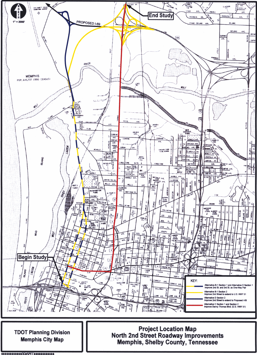
At the public meeting on September 24, 2003, three potential routes were presented; they are shown on this map [310k; PNG]:
Alternative B-1 would reconstruct 2nd and 3rd Streets south of Henry to carry three lanes of traffic in each direction. North of Henry, 2nd and 3rd would taper together and continue north, roughly along existing 2nd Street, as a six-lane parkway with three lanes in each direction and a 34-foot median. North of Mud Island Road, the route would cross the Wolf River, with the northbound lanes using the alignment of existing North 2nd, and become a six-lane freeway, with a trumpet interchange providing access to existing North 2nd/Whitney and the sewage treatment plant. The freeway (six lanes with a 22 foot paved median) would curve to the northeast and meet U.S. 51 at a reconstructed interchange with TN 300.
In addition, the ramp from I-40 westbound to North 2nd would be reconstructed to feed into Jackson Avenue, making it possible to access the Pinch District and Pyramid without looping around via Exchange and 3rd.
The new TN 300 interchange at Thomas Street (U.S. 51) would only make use of one of the existing ramps (from TN 300 westbound to U.S. 51 southbound). While the existing interchange is designed to accomodate a western extension of TN 300, the new design would provide for improved access:
Alternative D is similar to Alternative B-1 south of the Wolf River. Just north of the river, an at-grade intersection would provide access to existing North 2nd and the sewage treatment plant, and the route would continue north to a trumpet interchange with Proposed I-69. (The existing TN 300/U.S. 51 interchange would be reconstructed as part of the I-69 project.)
Alternative C would follow Auction Avenue east to U.S. 51. From the Auction/U.S. 51 intersection, Thomas Street would be reconstructed as a six-lane parkway with a 34-foot median, to meet the TN 300/U.S. 51 interchange in Frayser.
Members of the project team indicated that Alternative C is unlikely to be constructed, because it fails to meet the purpose and need of the project (namely, to improve access along the 2nd Street corridor); however, federal law (the National Environmental Policy Act or NEPA) requires the consideration of all feasible alternatives when constructing a new route.
Alternative D would be constructed if I-69 runs through Memphis; if the proposed I-69 follows the outer beltway instead, Alternative B-1 would be used. Memphis officials suggested that much of the expense of the route would be paid out of I-69 funds if the route did go through Memphis.
The preferred I-69 route through the Memphis area (Alternative A) would follow TN 300, then turn to the north. The route marked with the thick red line on the map represents a possible route.
The map on this web page reflects a possible configuration of I-69 and TN 300 if both projects were completed. It also shows the configuration of a completed interchange at U.S. 51, based on aerial photos and personal observation of the site grading.